The Sedona Friends of the Forest
The Sedona Friends of the Forest (FOF) is dedicated to assisting the United States Forest Service (USFS) in maintaining, protecting and restoring the scenic beauty and natural and cultural resources of forest lands for the enjoyment and use of present and future generations. The objective of the non-profit, non-political, volunteer group is to work in partnership with the USFS, primarily in the Red Rock District of the Coconino Forest of north-central Arizona, in tasks it does not have the manpower or funds to accomplish on its own. We provide boots on the ground, we are dedicated, we have fun, we are goal-oriented, we get things done! Over 50% of our volunteer members actively participate in one or more of many ongoing projects. Over the past decade, the FOF has averaged over 35,000 volunteer hours annually, making us the largest and most active volunteer group supporting the USFS.
Photography And 3D Modeling Of Cultural Sites
The Red Rock District of the Coconino Forest has one of the highest concentrations of prehistoric and proto-historic sites on public lands in the United States. As a sub-group of the FOF Cultural Resources Committee, the site photography team has been photo-documenting archaeological and historic sites within the Coconino Forest since 2011.
To date, we have completed detailed photo documentation of over 600 sites in the forest. This work includes over 100,000 photos of artifacts, stone habitation structures, petroglyphs, pictographs, and archaeological features.
In mid-2016, Forest Service archaeologists requested that we investigate the possibility of acquiring 3D photogrammetry of some of our Native American cultural sites. At the time of the request, Travis Bone, the Forest Service archaeologist stated “photogrammetry is the future of archaeology”. We now know the 3D process to be an important upgrade to the documentation and evaluation of archaeological sites and information.
Within one week of that request, we acquired a demo version of Agisoft Photoscan and had completed our first test model of an artifact. Within one month, we had started uploading multiple models of rock art panels, cliff dwelling walls, and artifacts to Sketchfab. To date, we have uploaded over 1,700 3D models, primarily for the Forest Service archaeologists to be able to work with and review. The public availability of these models allows others to see evidence of the rich cultural heritage in our region and also allows our volunteer docents and visitors at Forest Service-managed Heritage Sites to appreciate a high level of detail and variety within the sites.
The hard work and dedication of Sedona Friends of the Forest volunteers has led to it receiving several awards.
- 2017 Forest Service Chief’s Honor Award for fostering volunteerism and innovation to the Red Rock Ranger District and the Sedona Friends of the Forest.
- 2018 U.S. Dept. of Agriculture Under Secretary’s Award for Volunteer Innovation to the Sedona Friends of the Forest.
- 2019 The Arizona Governor’s Archaeology Advisory Commission Award for Avocational Archaeologist for contributions to the Coconino National Forest Heritage Program.

Tools and Equipment
The equipment used in this work is provided by the volunteers. We currently use 24MP Nikon DSLRs with a wide variety of lenses and support equipment including tripod-mounted wireless triggered flash units, fold-out shades, ladders, Macbeth color charts, scales, and, where legal, aerial drones. Field teams are sent out with camera bags stocked with cookies.
We quickly learned that processing detailed models on a basic laptop computer was not going to be sufficient. A 32GB RAM workstation with quad processor was acquired on eBay by a team member. Within a year it was replaced with a 96GB RAM dual hex core workstation with GTX 970 GPU, also sourced on eBay. Due to the size and number of input photos, we have reached maximum RAM usage a number of times.
Due in part to the cost involved, we started with and continue to use the basic version of Agisoft Photoscan/Metashape software. The measurement capabilities of the pro version would be beneficial for some of our work if not for economic constraints. We have developed several workarounds, including the measurement facility within Sketchfab, that do work reasonably well for us. Although not included within our models, every area modeled has reference photos available with scales and color charts for future comparison.
Why We Do What We Do
The large number and variety of archaeology and historic sites require significant effort to document, monitor and preserve. The cultural sites are under constant assault by both natural and human impact.
The first aspect of site documentation is to record what is in place in the forest. As sites are lost or damaged for whatever reason, we aim to provide a record of what is, or was, there to begin with, for future review by researchers. Traditional photography has played a large role for almost two centuries. With improved technology, including 3D photogrammetry, the quality and application of the documentation have evolved dramatically.
By adding 3D photogrammetry to our technical arsenal, additional detail and measurement statistics are now available to the archaeologists. The reference photo sets that we and earlier workers acquired are frequently used to evaluate change over time at the various sites. Once we started acquiring 3D photos, one unexpected benefit was the ability to use the models to more easily compare new imagery with old. It is frequently difficult to compare old to new, due to differences in photographic equipment and conditions during acquisition such as varying angles and lighting. We are now able to manipulate 3D models to closely match photos taken 10 to 130 years ago.
-
- Palatki Heritage Site, 1895. Photo by Jesse Fewkes.
-

- Palatki Heritage Site, 2017
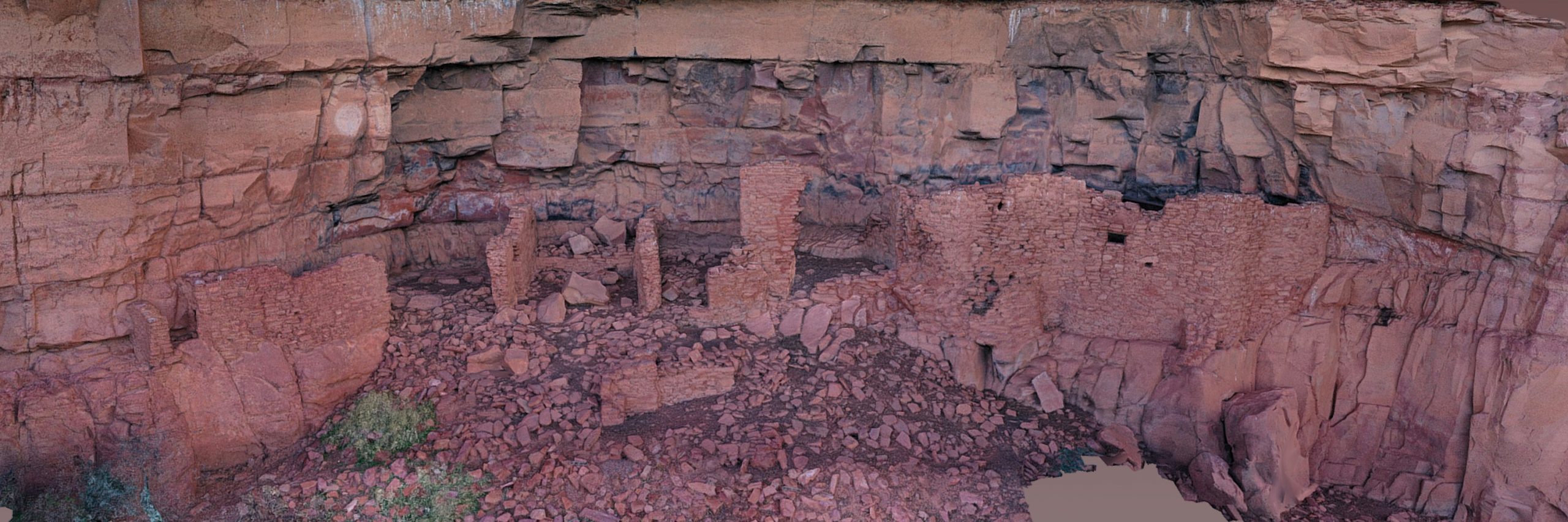
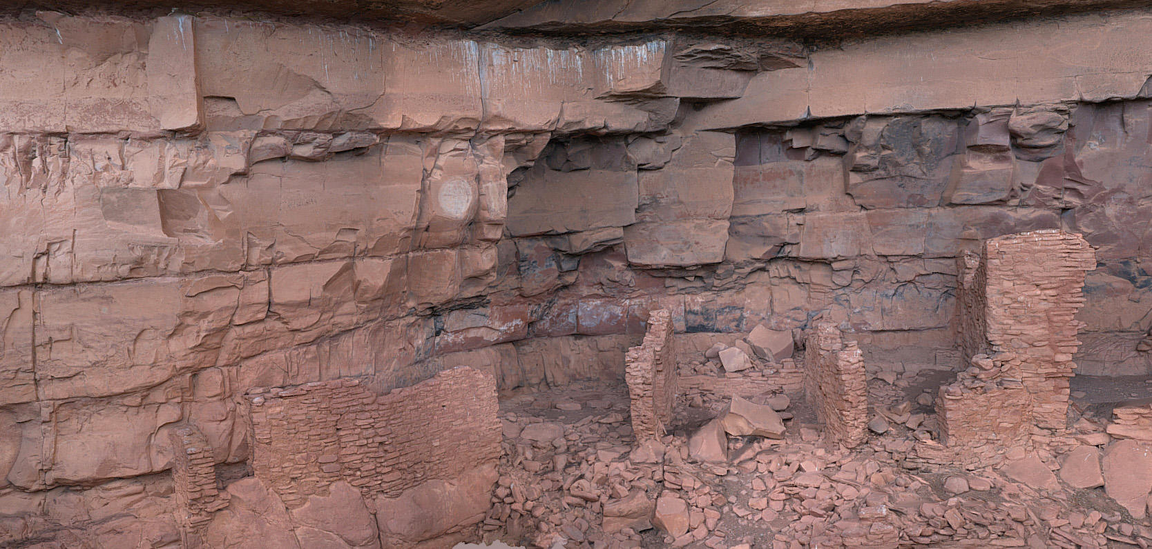
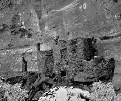
A good example of the application of this methodology is the comparison of rock art panel 44a at the Honanki Heritage site northwest of Sedona. Detailed photo documentation of this panel was carried out prior to early 2014, when a natural fracture was identified but no rock movement was evident. Our model, FS0124, was acquired in August 2016, when at least 8 mm of movement was identified. Model FS1263 (below) acquired in July 2018 indicates approximately 20mm of movement and a new sub-fracture. A later model, FS1539, in May 2019 indicates approximately 24mm of offset, plus the sub-fracture has broken off a portion of the 400-600 year old pictograph. Application of these types of comparisons has allowed the archaeologists to identify numerous examples of natural and vandalism-caused degradation of pre-historic structures and rock art.
3D Acquisition Workflow
We use several different processes depending on the archaeologists’ requirements.
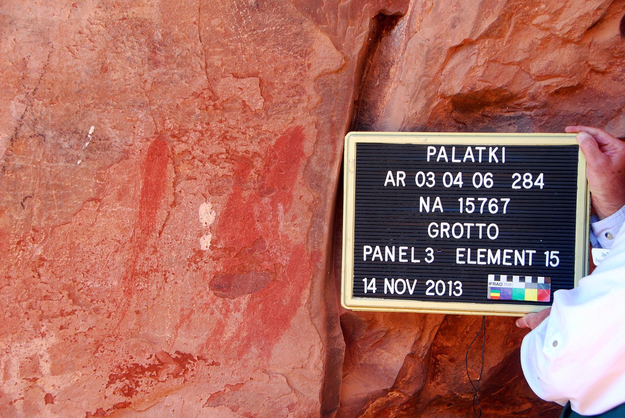
The vast majority of our work is related to on-site documentation of 800- to 1000-year-old Sinagua stone cliff dwelling walls/rooms, and 200- to 8000-year-old pictographs and petroglyphs on cliff walls and boulders. For the vast majority of these models, a photographer and technical assistant identify the subject, create a display board identifying the site, date, scale, and pertinent information and photograph it with the subject prior to 3D acquisition.
In general, scales are not directly included in the actual 3D models. In almost all cases we plan for 60-70 percent overlap of 3D photos and extension of the area one full image width beyond the area of interest, to ensure the area of interest is fully covered in 3D. Additional “angled” photos are taken of subjects, such as features in room walls, with complex 3D geometry to guarantee full 3D detail.
In many cases, room walls or rock art panels extend higher than eye level and helpers place and stabilize step ladders for the photographer. All team members are trained and exposed to every aspect of the acquisition, such that they can provide backup to the camera operator so “details” are not missed. We have, on occasion, used poles 10 to 25 feet high to lift cameras to high positions as required.
We frequently use zoom or manual aperture lenses. These have drafting tape applied to prevent unintended changes to aperture or focal length for any given 3D sequence. Every 3D sequence is marked by inclusion of a mug board at the beginning of the sequence or a marker photo such as a hand or face to facilitate organizing and processing after the photoshoot. In many cases we will acquire 50 models or more in one day and differentiating similar walls or rock faces can be difficult after the fact.
In all cases, the field team aims to acquire too many photos rather than too few, as some of the sites worked are very remote and require extensive hiking and climbing to access. We always aim to not be required to “go back” because we missed something. Over 600 sites have been photo-documented to date and there are thousands still warranting our efforts.
Because many of our subjects are within cliff face alcoves or the interior of ancient rooms, lighting is a major issue. We have developed a method in which 2 or 3 wireless flash units are triggered by a transmitter on the camera.
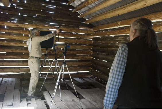
In order to avoid shadow detail degrading the 3D, we mount the flash units on tripods in a set pattern and spacing we have designed, such that the camera can be moved for 3D so we can get full coverage of the subject even if the room is dark. A successful application of this can be seen in Model FS1693, which documents the interior of a 100+ year-old historic cabin with very poor interior light. Three flash units were lined up and shifted, as the camera operator worked around the room. This structure has restored glass windows which were covered over with paper to prevent reflections. The paper was then removed during 3D editing. The room was very dark with deep shadows such that details were not reasonably visible while the team was on site. This model was only possible by using the flash units.

The same system is used for rock art models which are frequently photographed in areas of very poor natural light. Model FS1751 is a small area of a lichen- impacted 900-year-old petroglyph at the V bar V Heritage Site. The shaded, moist environment at this location is leading to extensive lichen growth which is damaging or destroying archaeologically significant petroglyphs. In collaboration with Arizona State University PhD Lichenologist Frank Bungartz, we are using high-resolution 3D to document and to attempt to measure the rate of change. The area in question is less than 6cm wide. Flash units are situated to provide lighting that allows reasonably detailed acquisition, carefully photographing very close to the rock face, with a handheld camera and macro lens. The quality of this type of model will not only capture the specific details required for lichen identification but will also permit measurements to be taken of the area and volume of the lichen growth, which are required by the lichenologists supporting the archaeological evaluation.
3D Processing Workflow
Virtually all of our models are processed using the standard version of Agisoft Photoscan and Metashape. Other software has been tested but the learning curve achieved with the Agisoft products has led to a high probability of success with excellent control of the parameters and, critically for us, batch processing of large data sets.
In all cases, photographs acquired with the DSLR cameras are acquired in Nikon RAW format (NEF), converted to DNG and edited as required in Adobe Camera Raw and Photoshop. The photo sets are imported to Agisoft as distinct chunks that are identified by site and subject. Typically up to 50 chunks may be included in one project to be run as a batch job. Although reviewed prior to importing to Agisoft, the entire project photo set is “estimated image quality” for issues missed during initial editing.
In all cases, initial alignment in the software is done at high or highest quality. We typically do not bypass dense cloud creation, which is also at high quality. Mesh generation is done at high quality and then the mesh is decimated to a value usually greater than 1 million faces to retain as much detail as reasonably possible for any required archaeological evaluation. Texturing is typically 4096 x 1 exported to PLY format. For specific models, a slight improvement going to 8192 x 1 or rarely 8192 x 4 (OBJ) is applied.
Ancient pictographs, in some cases, can be enhanced when the photographs are processed with color modification via DStretch software to apply color decorrelation stretch. We have very effectively created 3D models of rock art panels in the traditional manner and then applied Dstretch to the input photos and redone the models with the modified photos. (See below for examples).

Archaeological sites in the Forest are identified by a unique site numbering system created by the Forest Service. The models of these sites are uploaded to Sketchfab with a sequential model number that is cross-referenced to the site number for easy access when required. All photos utilized for the 3D processing are saved and cross-referenced by both Sketchfab model number and site number.
Some Of The Challenges Encountered When Working In The Forest
Many of the locations the 3D acquisition team need to photograph are remote sites in the forest or wilderness areas. Many of the sites require miles of hiking and non-technical climbing or scrambling to access the site. All team members use training they have received to follow archaeological site etiquette and “do no harm”.
As volunteers for the Forest Service, our first priority is safety. To date, we have not experienced a significant injury during acquisition. That being said, working in remote areas in an unstable environment can involve “issues”.
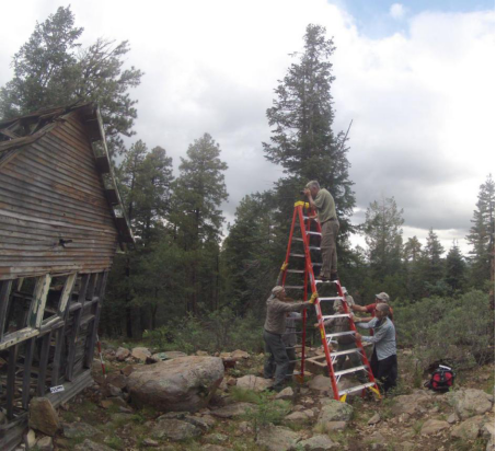
The Kendrick Mt. Cabin modeling effort referenced below required a team to hike 4.5 miles and up 2600 feet starting at an elevation of 8500 feet above sea level carrying all required equipment plus a ladder for the exterior models. They needed to do the work and hike back down before the weather became a safety issue.
The model below was acquired at a remote site with abundant rock art on the cliff face. As the photo team stepped up to the cliff face to start acquisition we encountered a local resident who was seriously displeased with our presence. While waiting for him to settle down and then leave, he was modeled. This is a common situation at many of our sites.
Technically, the greatest challenges we have faced are related to difficult light conditions and either very low light levels in cave-like conditions or very harsh lighting in remote areas where we can only carry in limited amounts of equipment. The scale of subjects we model varies widely from less than 0.1 square meter to cliff faces 100 square meters or larger with complex 3D geometry requiring additional light sources or shading. Many cliff alcove sites require shooting outwards from the cliff face at deeply shaded walls with bright Arizona sky shining over the top of the wall. Where possible we carry long poles and sheets to shade areas but in some cases the area requiring shading is too large or the sun position is not suitable.
We use any size material required to shade areas to avoid shadow impact on 3D model quality for both rock art and ancient room structures.


Many of the sites we work at are in wilderness or protected areas where we cannot fly a drone for high cliff face, roof or areal coverage, so we use poles and/or ladders.

The use of electronic flash units has proven valuable as long as the light sources do not move when working in a specific area.
Many of our 3D subjects were created by ancient people in remote locations that are difficult for us to identify and access. Finding and accessing the evidence of their activity occasionally requires interesting effort on the part of the team.


Some Sedona Friends Of The Forest 3D Models That Show The Variety And Complexity Of The Work We Do
At the lower end of the size scale, this is a Sinagua (800- to 1000-year-old) clay artifact found while doing 3D at a very remote site. It is the only example of its type found in the region and is believed to possibly be an effigy or doll-like design. It is less than 2.5 cm at its longest dimension.
The model below is an area at the Palatki Heritage Site Roasting Pit Alcove. The model is of a relatively complex rock art panel area with pictographs and petroglyphs from at least 4 and more likely 5 or 6 different prehistoric cultures. The screengrab of the Dstretched model earlier in this article uses the same input photographs processed using a Dstretch color decorrelation stretch algorithm. Detailed evaluation indicates additional pictograph detail or features not visible via the standard photo processing. Using different Dstretch algorithms allows us to identify additional detail.
This is one of the largest models we have created. It is a 120-year-old historic structure in the Sedona area that the Forest Service is developing a plan to partially restore. The model used 1147 24MP photos including many photos taken from a 20-foot high step ladder with multiple team members holding it in place. Although other detailed area models show some of the specific problems with wood rot and damage from vermin, most issues can be evaluated via the full structure model.
The first model is a full area model of the cliff face of the V bar V Heritage Site petroglyph panels. This area is approximately 30 meters wide and over 6 meters in height. Trees and bushes present in the modeled area limit some viewing angles. The trees, a major factor in the lichen growth, degrade the rock art but have been removed during 3D editing. The model was created prior to October 2018 when a natural rockfall severely impacted the internationally famous “calendar” panel.
A recent second model of the same area shows the calendar area after the rock and the fallen rock fragments on the ground. The availability of the pre-fall conditions and detail model of the area of impact would allow the partial construction of a 3D “print” of the stone if required. However, this is not expected to happen at this time.
Impact On The US Forest Service And Archaeology In General
The acquisition and availability of 3D models of local cultural sites provide the Forest Service archaeologists, historians, biologists, and environmentalists with a significant database of graphic information to compare with previous documentation in a relatively easy manner. The individual photos used in processing also provide very detailed information that might be missed by simple (non-3D) photo documentation.
The application of relatively new technology by the Forest Service and their volunteers opens many avenues for experimentation and evaluation in the future.
Perhaps the best way to capture the impact of 3D documentation is in the feedback we have received from the Forest Service specialists such as Neil Weintraub, Kaibab Forest South Zone archaeologist who uses the material we create:
These models are critical to preserving these fragile sites forever, especially because of the threat that wildfires pose to our many historic wooden structures. If we lose them in a fire, at least we will have a model that represents these places much better than just pictures. While many prehistoric structures and rock art are a bit more resilient than wooden structures, they are certainly just as threatened by fire AND vandals, making the 3D models just as critical for those.
There is value in the ability to have public interpretation of these places that are remote and difficult to access, such as the historic Kendrick Mountain Lookout Cabin. By viewing the model in 3D, the public can get a feel for the place that regular old pictures just can’t capture.
Your work is invaluable. While we acknowledge the value of your projects through volunteer hours contributed to the program, it might also be good to know what these models would cost in the private sector. It is an unbelievable donation of your team to Forest Service conservation and preservation efforts.”
Lessons Learned And The Future
The learning curve for both acquisition and processing has been long and complex for our group of volunteer non-specialists. We have received help from other groups doing similar work and from online tutorials and various other sources of information. With the lessons we have learned and with the publishing of most of our models, we have been approached by other organizations and individuals who do this type of work asking for help. Just as we had approached others earlier on. We have found the community of practitioners doing this type of work to be very supportive. It has been truly rewarding to pay it forward and help others who are further behind us in the learning curve. It is clear that as we continue doing this type of work, we are continually learning how to do it better and develop our own techniques.
Collaboration on projects with other organizations, agencies, and descendants of the original inhabitants has also opened up many opportunities benefiting the knowledge and preservation of the Native American prehistoric cultural resources in our region.
We are always looking forward to learning, developing, and utilizing new methods and technology.
If you are interested in our 3D and other activities check out the Sedona Friends of the Forest website.
About the author
Spence Gustav
Spence Gustav is a retired geo-scientist with education and experience in archaeology and geology. He is a past president of the Sedona Friends of the Forest and has led the volunteer cultural resources photo documentation team since its inception almost 10 years ago.