About me
Hi, I’m Marc Flamm, and I have been in the commercial drone industry since 2014. Focusing on support, sales, and training, I have worked with thousands of enterprise drone users to help them integrate Unmanned Aircraft Systems (UAS) into their workflows. I am currently the Enterprise Program Manager at Skydio and am focusing on the successful implementation and delivery of Skydio solutions for Enterprise customers. I am also a current FAA part 107 remote pilot and ITC certified Thermographer. Outside of work, I am an avid aerial photographer and when I am not flying drones for work, I am flying for fun!
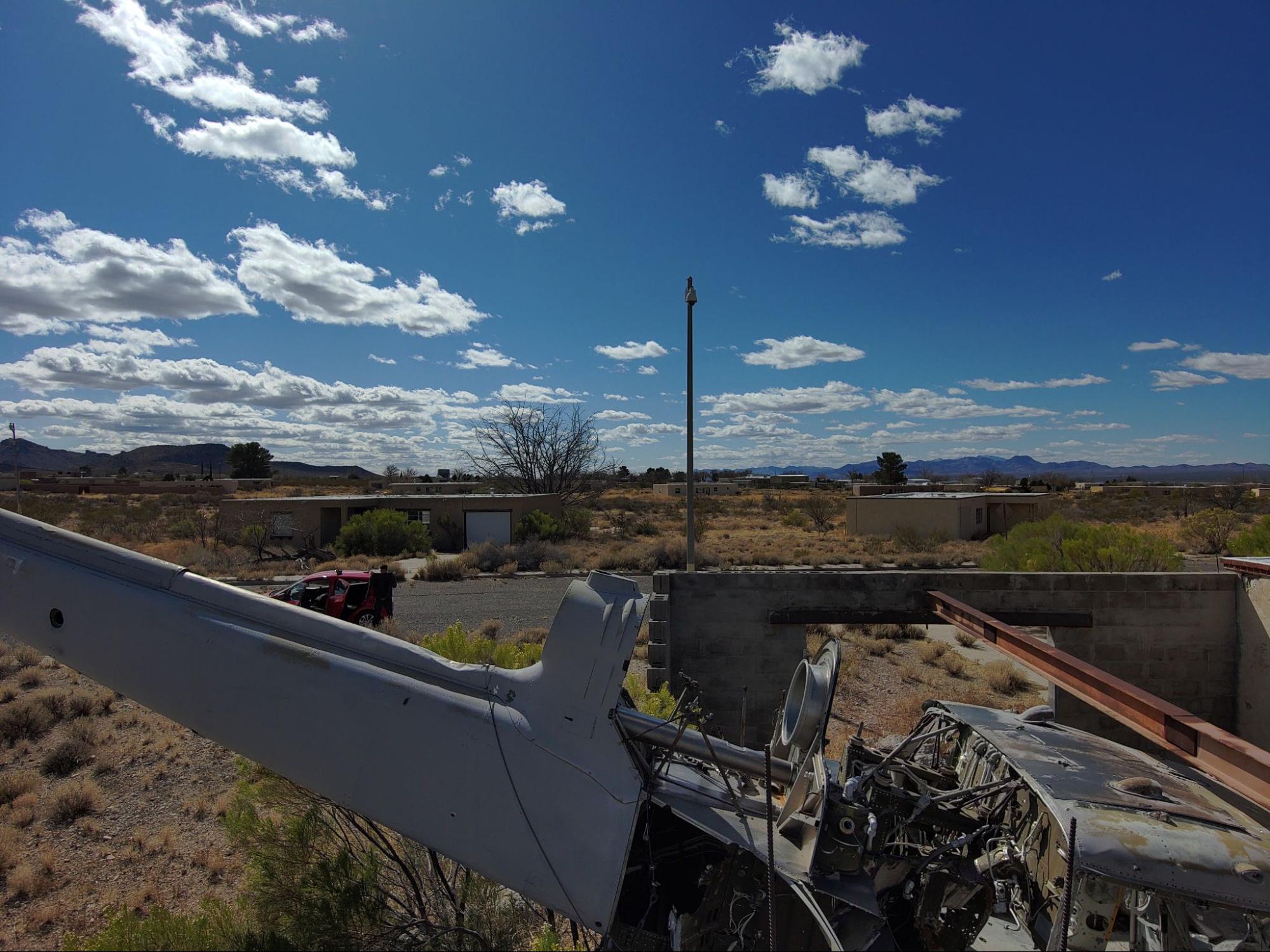
Mock helicopter crash site 3D model
In the past few months, I have had the joy of watching Skydio’s new 3D Scan technology come into being through a monumental effort by so many of Skydio’s Product Management and Engineering teams. As we develop the software, our flight testing teams and early access customers conduct flight after flight to make sure the technology is effective and easy to use. And I contribute for my part by testing the software in as many interesting environments as I can.
The site where this model was scanned is located in a research and testing facility for first responders and is used for various training exercises, including scenarios that involve helicopter crashes. In most crash scenarios, whether they involve aircraft, cars, or other vehicles, first responders need to focus on many things at once, including saving lives, clearing the site as fast as possible to minimize disruption, and documenting the scene of the incident. Drone technology promises first responders the ability to inspect these crash sites efficiently and accurately and generate high-quality data documentation with ease.
Preparing emergency workers to respond to and document accident scenes
The inspiration for this 3D model came from a desire to help first responders and aircraft inspectors streamline the process of inspection and investigation. I hope that this example helps demonstrate the incredible applications of high-quality 3D models for first responders, investigators, and inspectors.
Post-crash investigations can be time-consuming and expensive for first responders, not to mention socially disruptive if they require area closures or lane blockages. Depending on the severity of the crash, these investigations can take days or weeks to complete. The ability to quickly and easily create high-quality 3D models of crash incidents such as this one streamlines the investigation process by allowing expert investigators to explore the site virtually rather than having to travel there in person. These 3D models can also serve as high-quality documentation of the incident, preserving the site in its original state.
Another use case for this 3D model is to provide real-world training requirements for first responders. With the 3D model, a training instructor can virtually navigate through a crash incident of this type and explain what the first responder protocol is in this situation.
Creating these 3D models is easier than ever with Skydio 3D Scan, a new software solution for Skydio drones that almost completely automates the process of capturing a complete dataset of images from any scene.
Skydio 3D Scan: A revolutionary new way to capture photogrammetry data
Skydio 3D Scan is a first-of-its-kind adaptive scanning software built on top of Skydio Autonomy, the autonomous flight engine behind every Skydio drone. 3D Scan allows the drone to automate the data capture process with comprehensive coverage and ultra-high resolution, so that crews can perform higher quality scans in less time and with minimal pilot training.
Skydio 3D Scan has the potential to transform the way assets are digitized in order to be inspected and analyzed. In the photo above, you can see me in the background while the drone independently scans and photographs the site.
To use 3D Scan, all I had to do was turn the drone on, set a floor, a ceiling, and four points and then press go. 3D Scan is so easy to use that you can be up and running in five minutes. After I pressed go, the drone did the rest of the scan itself. Skydio’s Adaptive Mapping algorithms independently helped the drone design a unique flight path specific to the helicopter crash site. The Skydio vehicle autonomously flew around to explore and model the site, and then it automatically executed an image capture plan to provide efficient and complete coverage, with full obstacle avoidance engaged. In 43 minutes, the Skydio 2 took 542 photos, and all I had to do was swap the batteries once and watch it fly. I processed it with Bentley ContextCapture, though the images can be processed in any standard 3rd party photogrammetry software, and then uploaded the scene to Sketchfab for viewing.
 This photo shows the unique image capture plan that the Skydio 2 autonomously created for this site, so all the pilot has to do is sit back and watch.
Sketchfab: A fantastic tool for rapidly sharing outputs
Once Skydio captures the data, and a photogrammetry engine turns it into a 3D model, Sketchfab has a number of useful features that help model users quickly digest and share the outputs. Annotations (the numbers in the photo above) allow the model’s owner to pin specific spots on the model and name them, enabling the model’s viewers to quickly jump to an up-close view of that spot. In addition, the Matcap view (pictured above) provides a unitone finish that offers a quick and easy visual guide to the geometry of the model’s surface, which can help identify defects on the model.
We at Skydio use Sketchfab both internally, to pass 3D models between our field representatives, product managers, and engineers, and externally, to share models with customers. We are excited to soon share 3D models on our website using the Sketchfab APIs. We share Sketchfab’s goal of democratizing 3D models. Just like Sketchfab has made it as easy to share a 3D model as it is to share an online video, Skydio 3D Scan is designed to make capturing the data for a 3D model as easy as shooting photos and video with a cell phone. We look forward to sharing many more models with the world as happy Sketchfab customers!
Coming Soon: Skydio’s biggest event ever
A celebration of this new era of autonomous flight will take place at 9am PT on June 2, 2021, broadcasting from the U.S. Space & Rocket Center. All are welcome to join virtually to learn from Skydio’s senior executive team, speaking from hallowed ground for the US Aerospace Industry. Register today to join CEO Adam Bry, VP of Customer Success Alden Jones, VP of Autonomy Hayk Martiros, and a special customer guest as they showcase our latest technology.
We’d like to thank Sketchfab for supporting our event as a launch sponsor, as well as the other companies joining us in the celebration of this new technology: Bentley Systems, DroneDeploy, RealityCapture, and Sundt Construction.


