
About
I am Professor Timmy Gambin, an Associate Professor of Maritime Archaeology at the Department of Classics and Archaeology, University of Malta. The Department of Classics and Archaeology has established an underwater mapping project that aims to map the seabed of Malta’s territorial waters as well as ongoing 3D documentation surveys of various underwater sites and objects.
The University of Malta works in close collaboration with a number of partners, namely the Superintendence of Cultural Heritage and especially with the Underwater Cultural Heritage Unit within Heritage Malta.
I have no formal background or training in 3D but two team members (Kari & John) are what I consider to be 3D gurus. I always believed in 3D as a crucial factor that could help maritime archaeology—both in fieldwork and in the sharing of underwater sites. I was lucky to meet Kari Hyttinen who was way ahead of what we were doing in Malta. Since then we have developed, together with local diver (and now fellow 3D specialist) John Wood, a number of initiatives.
We use 3D for a number of reasons—to record archaeological excavations, to better understand underwater sites that often cannot be seen in their entirety (due to limited visibility), and last but not least, to share sites with fellow academics and the general public alike.
Workflow for Underwater Cultural Heritage
Our typical workflow involves remote sensing surveys, diver surveys, computer processing, and finally public sharing. The UNESCO Convention on the Protection of the Underwater Cultural Heritage considers preservation in situ to be best practice. This is where remote sensing comes in. Remote sensing refers to the use of robotics, controlled from a boat on the surface, to collect large amounts of information in a short amount of time and usually at depths greater than accessible to divers. The data that is generated from this workflow has a multitude of uses, ranging from site location and identification to policy decisions and public outreach programmes.
Side-scan sonar is one of the primary remote sensing tools. Since 2006, the University of Malta has been conducting offshore surveys aimed at locating, documenting, and recording submerged cultural assets. Results from this ongoing project feed into a programme of protection and management based on a comprehensive knowledge of underwater archaeological sites, allowing heritage regulators and operators to make informed decisions on best practices. The sonar is ‘flown’ along a regular pattern that is predetermined using specialised planning software. Each survey block consists of about 25km² and the sonar system is interfaced with a precision GPS, ensuring that all captured data is geo-referenced. Surveys were initially conducted using a towfish setup.

Essentially, the sonar is towed behind, or next to, any vessel capable of carrying the necessary equipment. The depth of the towfish is controlled by the length of cable used, the towing speed and direction. In recent years a different set-up has been used, where the sonar is mounted onto an Automated Underwater Vehicle (AUV).
An AUV is a device that integrates GPS, navigation systems, propulsion and direction modules, and a central computer to understand the environment that surrounds it. This setup allows the AUV to perform planned ‘missions’.
Our AUV has an EdgeTech high- and low-frequency side-scan sonar, which is the main tool used during our surveys. With this technique, we obtain a 2D image of the seabed, which can be used to make measurements and provides extremely accurate GPS positions. Using this set-up, we are able to survey the seabed up to a depth of 500 metres.
-

- Side-scan sonar mounted on AUV ©University of Malta
-

- AUV ready to be deployed ©University of Malta
Once data analysis is started, we eventually begin to encounter what we call ‘anomalies.’ These anomalies could be potential anthropic elements, such as aircraft, shipwrecks, or a modern transport container. Once a target is marked, whether it’s clearly identified or not, a second dive is planned with the AUV in order to generate higher resolution data. This is achieved by flying the AUV closer to the seabed and by narrowing the gap between each survey line, as much as possible. When a target is recognised, the documentary research begins. For relatively modern remains such as aircraft and metal shipwrecks from the First and Second World War, common sources are utilised, such as aircraft line drawings, newspapers, and war reports.
-

- Example of identifiable target anomalies. © University of Malta
-

- Example of identifiable target anomalies. © University of Malta
Once a target is identified, a planned verification is organised.
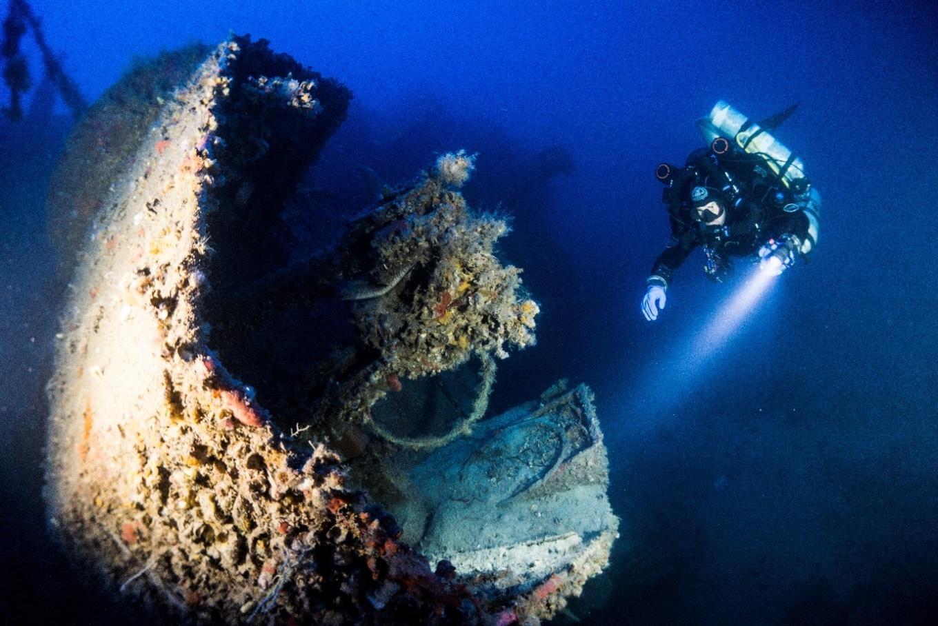
This is done through the use of a Remote Operated Vehicle (ROV). ROVs are equipped with cameras and lights in a watertight housing and are propelled by thrusters that control and provide stability. The type of ROV can range from small and relatively simple to large with multiple manipulators, video, camera, tools, and other equipment. The ROV utilised in this case is the Gladius Mini, equipped with a 4k camera, lights, and a five-thruster propulsion system capable of reaching depth up to 100 metres. The ROV system provides the first imagery of a target and helps us to identify, or not, a potential site. These first images provide insights into the marine environment, the topography, and type of seabed, providing important input on all those elements that help define a site. Once the ROV has been deployed to the site and underwater cultural remains are confirmed, the next step in the workflow is the use of divers to inspect the site. This step is dependent on a multitude of factors, chief amongst which is site depth. Divers are only used for manageable depths; sites that are discovered outside of this limit are only recorded through ROV footage. Diver inspections provide more in-depth insights into the nature of the site, allowing specialists to gain first-hand impressions such as site extent, signs of damage and collapse, types of marine growth, and various other elements. These inspections also help determine whether conducting 3D surveys is a viable option.
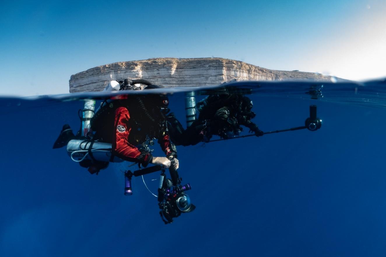
Since 2015, the University of Malta has been developing a low-cost 3D modelling process in collaboration with Finnish colleagues. Using 4K video footage, thousands of photographs are used to create accurate and scaled 3D models. The digital 3D models are created from sets of overlapping photographs. Depending on the size and complexity of the wreck and on the visibility of the water, many hundreds, if not thousands, of photographs are required. Photographs are taken using high-resolution mirrorless cameras in waterproof housings. Strong lights are used to light up the wrecks and to capture the colours present. Once the photographs are taken, they are loaded into a computer and processed in a highly specialised software. The captured data is processed in Agisoft Metashape. The model can be built in Metashape itself or exported into RealityCapture. This part of the process can also be time-consuming, with processing time increasing according to the number and resolution of the photographs. In order to produce accurate results, the overlap between each consecutive photograph should be around 80%. The size of the underwater site or wreck will very much determine how many hundreds or thousands of photographs are needed. The nature of the dive also needs to be taken into consideration since the deeper a diver descends and the longer time is spent at depth, the more challenging the dive becomes. One of the main reasons for this is stringent safety protocols and lengthy in-water decompression.
-
- Divers getting ready to conduction a 3D survey © Kristof Goovaerts
-

- Divers on decompression after dive to 110 metres © Kristof Goovaerts
Planning a 3D underwater survey is not straightforward, and requires that all necessary equipment is available and functioning, both in terms of equipment needed to safely perform the dive and the equipment needed for the photogrammetric survey. An important part of this is checking and double-checking the watertight camera housings, since a nightmare scenario usually revolves around an aborted dive due to a flooded camera. Apart from the physical gear are the safety precautions, including the presence of surface support and support divers, all trained for emergency protocols, and a fast RIB (rigid inflatable boat).
In recent months a new method for 3D documentation has been developed. The use of a Diver Propulsion Vehicle (DPV) or underwater scooter, has the potential to greatly enhance the ways in which underwater 3D surveys are conducted. John has been developing a scooter-mounted camera rig that permits team members to cover larger wrecks with less effort. This will enable the recording of shipwrecks in high-resolution over a shorter period of time. In turn, this means that we can focus our attention on the ‘next’ wreck to record.
Results – virtual museum, 3D flythrough, and VR
The results of this workflow have varying purposes. The 3D models serve as baselines from which the preservation and condition of underwater sites can be monitored. This is applicable both in terms of the cultural and natural heritage present on the site. This data allows heritage managers to create access protocols that are site-specific. Recurring site inspections may be compared to these baselines and if damage to the site is evident, access parameters may change. Apart from the management applications of these workflows are public outreach and public access considerations. The data captured throughout the photogrammetric surveys can be expressed in a variety of ways.
The Virtual Museum – Underwater Malta is an online platform that is designed specifically to present underwater sites through virtual means. The museum was designed specifically as a public outreach tool and the idea behind its creation was to bring Malta’s underwater cultural heritage to the surface. The virtual museum seeks to provide an informative and educational experience to all sectors of the public, be they divers or not. Visitors to the museum can explore underwater sites through 3D digital models and flythroughs, virtual reality, photographs, and information panels. The 3D model is an accurate digital reconstruction of the site and the flythrough allows visitors to explore the site up-close or zero-in on specific features. The applications of virtual reality (VR) as a public outreach tool rests in its ability to provide an emotive and educational experience, allowing visitors to really explore the site, as up-close-and-personal as a diver would. We strongly believe that such outreach tools are integral to communicating the value of a site to the public, and in return instill a sense of awareness within viewers, even if the site remains physically out of reach. Such an approach can be viewed as best practice in terms of balancing preservation in situ and public access. The Virtual Museum-Underwater Malta makes use of Sketchfab in order to host 3D models for public viewing, available for use on mobile devices, PCs and virtual reality headsets. Models hosted in Sketchfab can be accessed from the virtual museum itself, or alternatively using the Sketchfab website directly.
Future of 3D
Advice for 3D beginners
For work underwater, this is undoubtedly the way forward. I believe that this is true not just for the field of cultural heritage but for other fields too—including the offshore industry. My advice would be to grasp it, master it, and start using it sooner rather than later.
How 3D will change the field of Cultural Heritage
Simply put, I see it changing our field in more ways than one. Heritage managers can use 3D models to help with the protection, monitoring, and management of cultural assets. Models can also be used for storing and sharing information with colleagues from the heritage management and academic worlds. Last and certainly not least, 3D is an absolutely integral part of the future of outreach—this is especially true for underwater sites. Not everyone visits Malta, for example, and only a small percentage of those who travel to Malta can dive. With the help of 3D models, we can take visitors from anywhere in the world to a site at 110 metres, which would otherwise be inaccessible. Teachers can help create content to use these models as the ‘history books of the future’, making learning a fun experience and one that is more in tune with today’s younger generations.
A favourite model on Sketchfab
Although nothing beats standing in front of the real thing, one of my favourites must be the Rosetta Stone in the collection of the British Museum on Sketchfab. Such an iconic historical object that can be visited and admired from the comfort of one’s home – that is the essence of 3D and why Sketchfab is such a crucial tool for those working in the field of heritage management and museums.
About the author
Timmy Gambin
Associate Professor of Maritime Archaeology at the Department of Classics and Archaeology, University of Malta


