About Me
My name is Lina Jakaitė. I am a geologist by formal education and a self-educated artist. After working for years as an exploration geologist and having art as an after-work hobby I started to combine those two subjects recently. And it seems that interesting results can be achieved.
Since the very first day I started to work as a geologist I worked with 3D modeling. Not the artistic type, but geological 3D modeling using AutoCAD, Petrel, Global Mapper, QGIS, Surfer, and similar software. And 3D modeling was pretty much ‘an average day in the office’.
In geology, as in most other technical, engineering or other similar specialties, there are a lot of color-codings, conventional markings, and signs that are meaningful only to those who actually know the subject. The common joke is that when a geologist looks at a geological map and cross-section of the subsurface, they see the rock types, depths, thicknesses or even the paleoenvironment and tectonic activity of that region. But when the non-geologist looks at the same map and cross-section, they see…a lot of colors and weird shapes.
At some point, I started to look for the tools and ways that I could represent geological data and concepts to others in a way that would be attractive, easy to understand and might be a catalyst for them to look deeper into the science behind the image. That is when I discovered the artistic 3D modeling world with Blender, Substance Designer and Substance Painter, World Machine and Gaea, and many more. So, it started…from micro to macro scale, from minerals to regional geology.
Modeling Minerals and Rocks
One example of how theory can be illustrated in a way that it attracts the viewer is mineral classification schemes.
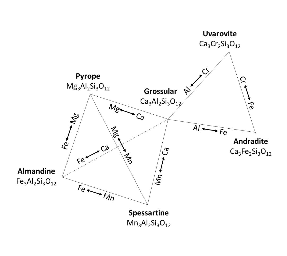
Many of those who had mineralogy classes have seen a scheme similar to this black-and-white scheme to explain the garnet minerals family.
There is a whole science behind that image, but shortly speaking there are some minerals which have the same crystal form, and almost identical chemical composition except that one or a few elements differ. It happens when those elements are similar in ion radius or in charge and therefore ‘like’ to occupy each other’s place. Each corner on this scheme represents the pure endmember of the garnet family, its name and chemical formula. It also shows which elements can easily substitute each other.
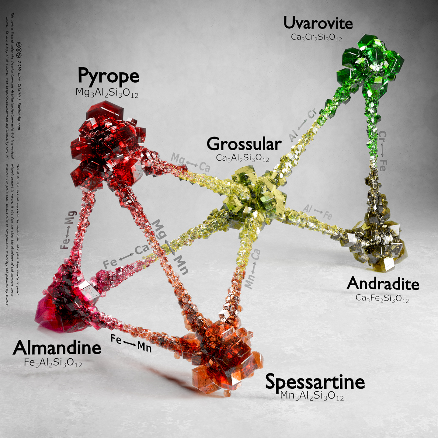
So, you have name and chemical composition information in there, but you still have to remember what each of these minerals looks like. So, I thought, why not put the mineral appearance information in there, too, and came up with this colorful illustration.
Of course, illustration like this cannot be 100% accurate. The color and crystal form variety in the real world are greater than shown, but for the sake of simplicity I chose only one mineral shape for all garnets and the most common color for each garnet mineral. Anyway, based on the reactions and responses on social media, I understood that an illustration like this works very well as a popular science tool. It is an ‘aha!’ moment for some people, raises discussions for others, and helps teachers and lecturers to explain the theory to students.
I have made a few other classification schemes and there are a bunch of ‘could you make?’ ones waiting for their turn.
There are few reasons why I model minerals and rocks instead of using photos of real samples. First, it might be quite difficult to get the entire variety of certain minerals or rocks. Second, the specimens might differ too much in size, weathering, representative shape, etc. so that it is impossible to make an eye-appealing illustration.
Sometimes, when I model a mineral or a rock as practice or prepare some new materials for a new project, I create a simple scene for it, just to show the mineral itself, like this:
or this:
Modeling Subsurface and Terrain
Another type of model I love to create is large-scale geological models. Those can be roughly divided into three groups: subsurface data-based, surface data-based, and artificial.
Subsurface data-based models are the most challenging since they need a lot of data integration and, even though I make it ‘artistic,’ it still needs to maintain accuracy and needs to be representative. All geological data, like depth maps, structure elements or well data, need to be exported from GIS-based software into a 3D modeling program, like Blender. The surface data usually need to be cleaned, corrected, cropped. It is very often the case that the geological layers and surfaces need to be recalculated from triangulated surfaces into quad surfaces. Also, the mesh density needs to be lowered so that unwrapping and working with the surfaces becomes a lot easier.
When it comes time for texturing, the lithological descriptions of the area and within the wells are of the primary importance. And Substance Painter and Designer are the main tools there.
An example of a subsurface data-based model can be seen in this short animation:
https://www.instagram.com/p/B2Uw5CKHGEW/
That animation shows a piece of west Lithuania and its geology with a highlight on an oil field. Again, it is made more like a fun animation, but it actually shows the real geological data, real structural situation, depths, faults distribution, layer thicknesses, their relative distribution and all else.
My main data are elevation and satellite imagery data when I create terrain models like this:
However, to make it more appealing to the eye, I take care that no original shadows are left. Otherwise, I cannot use my own light setup, or the model and light sources will look wrong. If the resolution of the data is not detailed enough and the model looks ‘washed out’ I use various tools like Substance Designer or QuadSpinners Gaea to ‘add details back’ into the model. Also, I consider the surface type (water body, forest, snow, etc.) and make the roughness, normal and other PBR maps accordingly.
As practice and for fun, I make artificial landscapes. Knowing my tools and workflows better helps me improve real-world data when needed.
Future
I started to share my work on various platforms just recently and the list of ‘ideas and models to make,’ both my own and those suggested by others, fills up faster than I am physically able to make those models. A large part of the work that I do cannot be shared because it’s often work done for a client and includes data that are not supposed to be published. But I am sure that there will be a lot more models in the future uploaded here on the Sketchfab, posted on Instagram, Twitter, LinkedIn, or on my own portfolio-type website.
I myself, and many other people, too, like to touch things, look around them or manipulate them. I’m ashamed to admit it, but even though I knew Sketchfab existed for quite a long time, I never actually took a closer look at how it really works. I set up an account here when I needed to show a client how their requested model would look and found out how easy the platform makes it to upload and share models.


