About Me
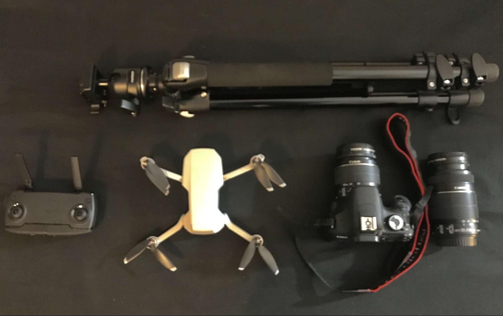
Hi, I am Apoorv Avasthy, a master’s student of Geology at Ludwig-Maximilians-University of Munich, Germany. Being in the final semester, I am working on my thesis project, which is based on the idea of applying virtual reality tours and photogrammetry in Geosciences for educational purposes. The motivation for this project came after I attended a seminar about surface deformation analysis using a UAV. This led to a discussion with my advisor Dr. Sara Carena and we agreed upon making a virtual field trip that could be used by a large group of students to learn field geology. My passion for scanning and generating 3D models is quite recent and I used two Dji Mavic mini drones (one personal and another from the university) and a DSLR camera to carry out the scanning work.
Field work is an integral part of geology. It’s important to visualize and examine what one reads in a textbook and that is what makes field excursions so important in geology. With this project, we are trying to incorporate a large amount of geological data (obtained on the field and in the lab) into a virtual environment that would help in understanding field geology in an interactive manner. This has become especially urgent and relevant in light of the recent coronavirus outbreak, as worldwide travel restrictions and social distancing rules have made it impossible to organize field excursions or even indoor rock labs in the near future. So my immediate, practical goal is to have a virtual tour for geoscience students ready before the end of this summer.
Project Details
The science and technology of virtual reality and virtual tours has been applied in many scientific areas and the results are promising. However, implementation in the field of Geosciences is limited and several authors have recently remarked how important it is to lower barriers to field trips for students due to funding problems,large student numbers, physical disabilities, lack of exposure and no prior field experience. This project is based on using low-cost methods to collect a large amount of data while striving for good quality in both data and models. This project has three main components:
- scanning of geologically significant outcrops and generating digital outcrop models (DOM),
- incorporating these models along with other relevant geological information in an interactive virtual environment, and
- processing these models in different types of software to obtain the spatial orientation of structural features (e.g. fracture planes, layering, fold axes, etc.). Due to the funding limitations in a public university, we also had to make sure to keep the project cost-efficient and obtain the best possible results without using any fancy and expensive pieces of tech.
Efficient execution of this idea demands a considerable time investment, both in the field and in the lab. We spent two weeks in a classic geological didactic location in southern Spain (Cabo de Gata natural park and surroundings) where my university has conducted field courses for a decade. During this period, a number of geologically significant outcrops were scanned by a team of two people. Working in pairs is necessary to reduce the risk of crashing the drone, and to speed up the process of compiling outcrop information. Most of these outcrops were scanned using a DJI Mavic mini drone. Since this drone lacks a software development kit (SDK), it was manually controlled and efforts were made to maintain a good percentage of overlap. A DSLR camera was used in cases where smaller and high resolution models were needed.
In addition to that, a number of pictures were taken near each outcrop to make a 360° image. The scanning team also recorded the relevant geological information at each outcrop (e.g. rock types, bedding orientation, structures, etc.) so that a description of each model could be attached later. Post-processing involves color correcting images and then importing them into Agisoft Metashape Pro for generating 3D models. The software has an intuitive, user-friendly interface and it is quite easy to use. However, a good system configuration is required in case the outcrop scanned is large (with hundreds of pictures) and the required output model is of high resolution. Because the drone records the horizontal position of each photo reliably, the 3D model will be properly oriented in space, which is necessary to carry out geological measurements.
To create virtual tours, I used 3DVista tour creator. It is a professional tour creator software that allows users to integrate 360° photos with a number of interactive features (info window, photos, videos, 3D models and many more hotspots), and deliver a tour that can be watched on any device. A great feature of 3DVista is that it is super easy to make your virtual environment compatible with any VR headset.
To carry out measurements of geological features in 3D models, software like GeoVis3D and LIME1.1 have been used. Other software is being tested too, but so far these two have been the most promising in terms of affordability and ease of use for students.
The 3D outcrop models can easily be uploaded on Sketchfab, as it accepts a wide range of formats, and annotations are helpful in guiding a viewer through the model. Another useful feature for me is inserting markdowns that allow me to insert images to show greater details.
Outcomes So Far
Using a drone helped in scanning a large area quickly and made it possible to scan places that are either inaccessible or where the risk of injury is too high for something that is just an educational exercise. The drone-acquired 3D models show areas that extend more than 100 meters, and the quality obtained is very good for a drone of this size and specifications. Geological information gathered in the field is incorporated using annotations and markdown images. Efforts are being made to incorporate information in a way that allows even people without a background in geosciences to appreciate the models.
The model below shows a textbook example of a normal fault with a core of fault breccia, and structures that indicate the sense of slip of the fault.
Another model shows the scan of a fault gouge zone (i.e. rock crushed to dust by the fault) that is 100 meters long. The use of a drone made it possible to scan the outcrop on both sides of the ridge. This allows us to measure the direction of the multicolored gouge stripes, which is best done from above and thus very difficult to do in the field. The model texture in this case was kept at a lower quality since the main focus was not to look for small scale structures.
The model below instead has a high resolution texture. This was necessary as it was important for the viewer to see the small pumice clasts in the ash and pumice-rich lower layer.
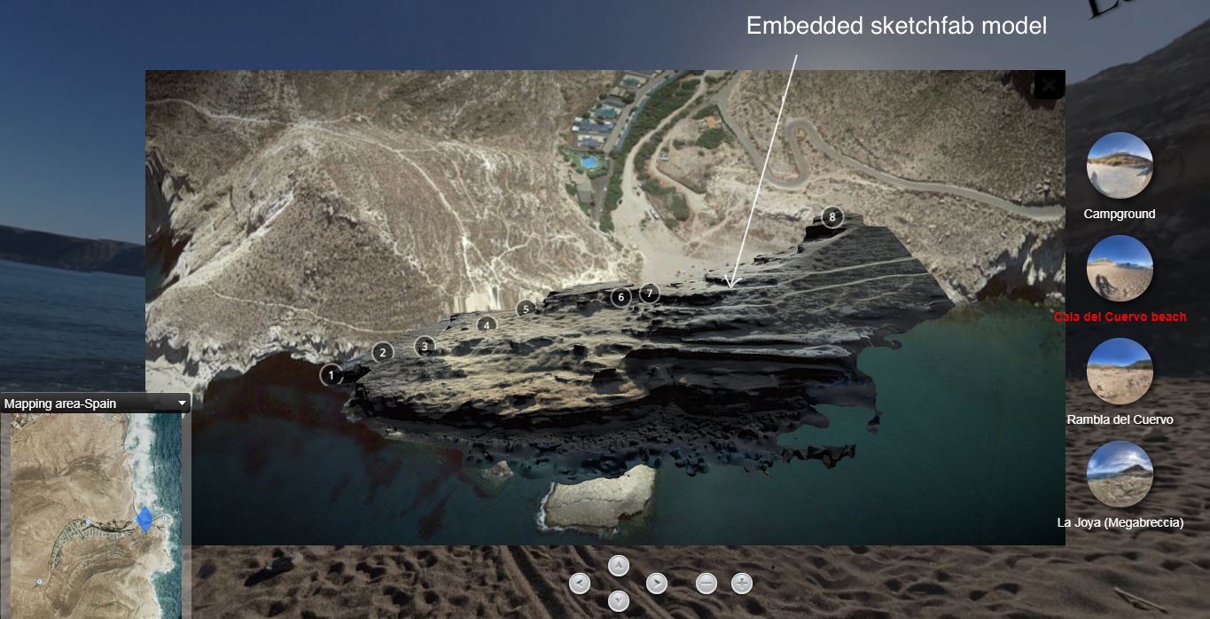
Using 3DVista, a virtual tour is in the making. I was successful in embedding 3D models into the 360 scene, allowing the user to open it by clicking on interactive hotspots. Images attached below show a snapshot from a virtual scene. The first image[SC1] shows how an outcrop gets highlighted when a user hovers the mouse pointer over it. The second image shows the window that appears after the interaction displaying the 3D model. Sketchfab allows an annotation auto-pilot feature that moves you automatically from one annotation to the other.
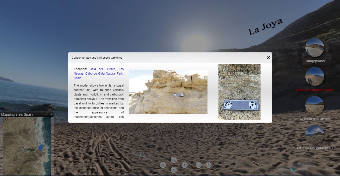
The image given below shows a snapshot from a scene created using 3DVista.
The map in the lower left corner shows the user their current location along with the field of view radar. Viewers can also easily change the map type (satellite/topo) by clicking on the drop down menu at the top of the map viewer. Thumbnails on the right side show important locations, allowing the user to jump directly to their place of interest. Background audio guides the viewer throughout the tour and even provides information about the geological history of the area. To view the information window, the viewer can click on the “i” icon (the image below shows the pop-up display window).
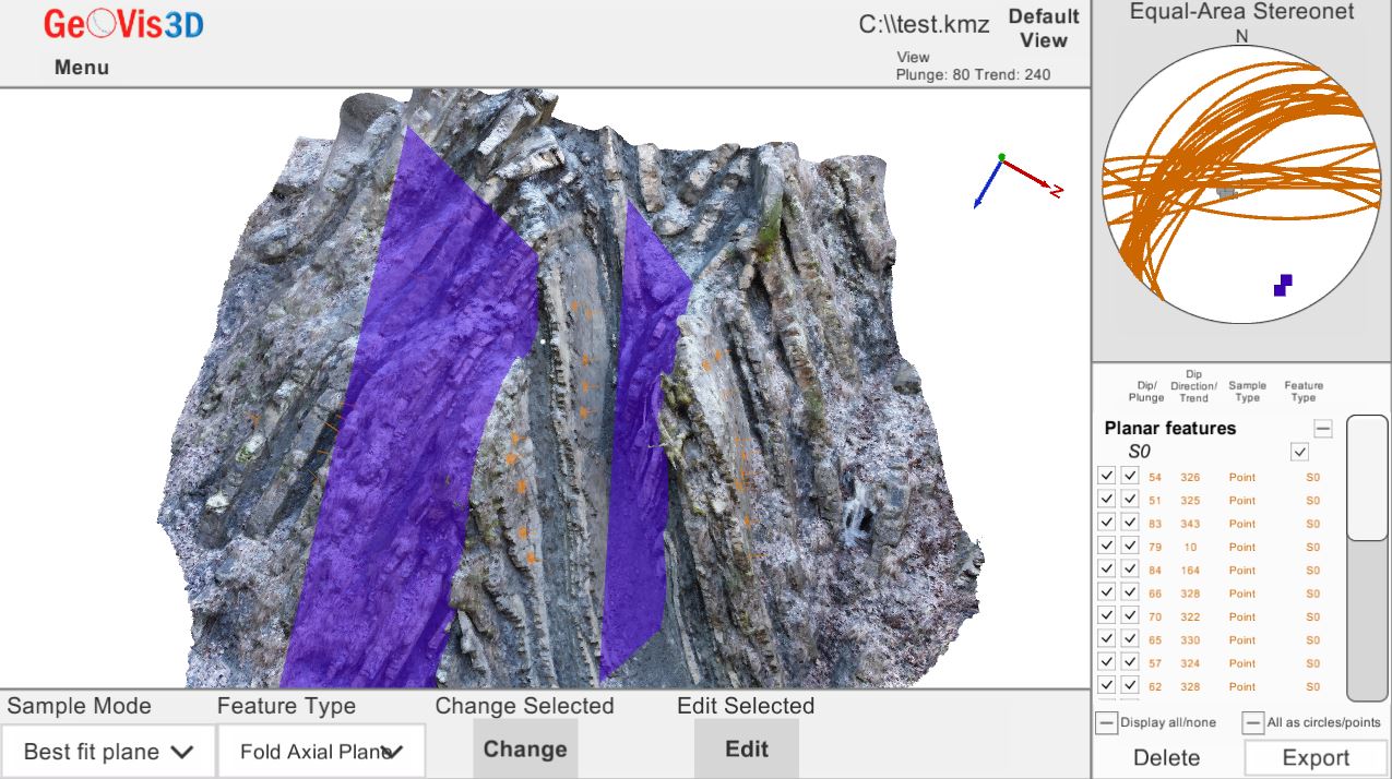
In addition to this, I used GeoVis3d to import the model (in .kmz format only) for extracting measurements. This is a Unity-built software that allows the user to freely rotate a model along all 3 axes and it makes extracting orientation measurements of structures very easy. The screenshot below shows the example of a model of Chevron folds in a flysch outcrop from Germany being used to measure folds. Orange markers show the points where the orientation of the bedding has been extracted. The blue planes are the best fitting fold axial planes. On the right side of the screen, users can find the stereographic projection plot with all the measurements (the software plots them automatically).
Advantages of a Virtual Tour
Every person who has studied or is studying geology knows the importance of field trips. However, not every institution or student can have adequate funding to carry out trips. I have personally met students who had only one short field excursion in the entire duration of their bachelor studies. In addition to that, some students are afraid of heights, or may not be strong hikers/climbers, or even have problems with basic mobility, or other health issues that preclude travel to distant locations altogether. Another problem is that many students don’t have any experience or prior knowledge about the field, which lowers their confidence by a great amount if they are taken to the field right away, rather than first letting them explore some geological features without the time pressure that comes with densely-packed field days. This virtual tour aims at providing a potential solution to some of these problems. A student can examine 3D models of hand samples, make observations by looking at models of big outcrops, observe a large area in detail, extract orientation information, explore areas that are impossible to access physically and much more. This virtual tour is also quite helpful in involving a large number of students at once as each of them can move through the tour and learn at their own pace.
This virtual tour would possibly fill the gaps created by not having enough field excursions at many institutions (due to funding issues, staff/students ratio, or unsuitable geographical location). Also, it will be a new and engaging way of teaching geology.
What’s Next?
The results obtained till now have proven very promising. However, there is still a lot of work left to do. A lot of 3D models are yet to be generated and due to the large number of photos and higher quality settings, it is taking longer than desirable. Another task is to digitize field maps, diagrams, sketches, stratigraphic columns, etc. obtained in the field and integrate them, in an interactive fashion, with interlinked 360° photos. Also, a handout needs to be written, to guide students in carrying out specific tasks that one usually does in the field (extracting measurements, making diagrams, answering specific questions, etc.). We would like to find out to what extent these virtual trips can replace an on-site field trip.
It is true that these VR trips cannot entirely replace the knowledge and experience gained by being physically in the field, but they would most likely be useful for introductory courses and can be adapted even for more advanced applications in case of needing to accommodate students with disabilities or, like this year, when traveling anywhere is simply not an option.


